Second Winter Storm Could Dump Another 8 Inches of Snow on These Regions

James Holden
Published Feb 23, 2026
With still over a month to go before spring officially begins, this winter has already shown us its fair share of extreme weather. From flooding rains in the west to bitterly cold temperatures down south, each week appears to be bringing one surprise after another. However, some places may not even have a few days to recover from the last big event after meteorologists warned a second winter storm could dump another eight inches of snow in the coming days. Read on to see which regions will be affected and how much you might see in your area.
RELATED: "Polar Vortex Disruption" Will Send U.S. Temps Plummeting—Here's When.
A Nor'easter brought heavy snow and wind to some areas yesterday.
Residents in the Northeast were treated to a pre-Valentine's Day winter storm on Tuesday. A Nor'easter dumped snow across the region, leading to more than 1,100 flight cancellations and 116,000 people without power, CBS News reports.
A last-minute change in the storm's trajectory shifted the brunt of the snowfall, with southern New England seeing much less than the foot it was initially expected to receive. In the end, Boston saw a scant 1.5 inches, while southern parts of Massachusetts saw as much as 8.2 inches accumulate by the end of the day, according to a National Weather Service (NWS) bulletin.
Pennsylvania was also spared any overwhelming amounts, with Philadelphia seeing less than two inches over the course of the storm. The heaviest hit was the Poconos and Lehigh Valley, which received more than a foot, per CBS News.
However, New York had decent snow accumulation across different parts of the state. New York City's Central Park saw 3.2 inches fall, while Coney Island in Brooklyn totaled six inches by the time the storm moved on. Areas just north of the city saw much more, with 11 inches falling in the Hudson Valley.
RELATED: Meteorologists Warn That "Super El Niño" Could Lead to Intense Hurricane Season.
Another storm is set to bring more snow and freezing temperatures this week.
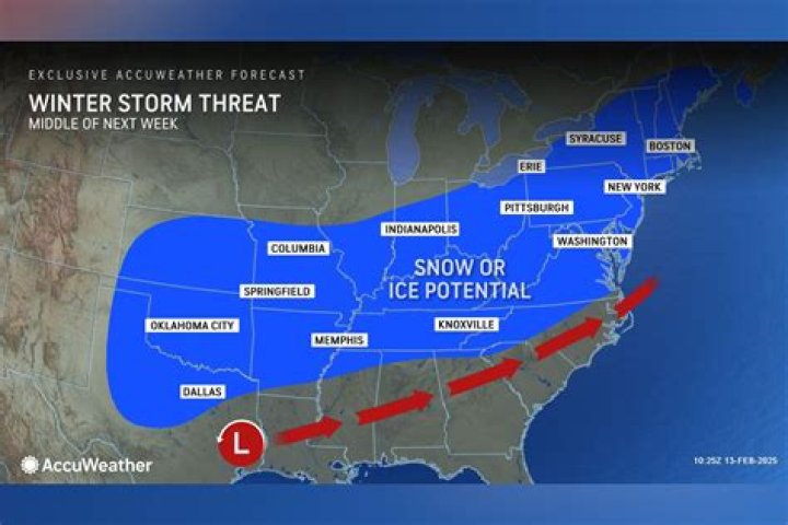
Even if Tuesday's storm fell somewhat short of initial expectations, residents in many places may not even make it to the weekend before they see fresh snow again. A new weather system is expected to pass through the Midwest this week, bringing more of the white stuff and bitterly cold temperatures along with it as it sweeps across to the East Coast, AccuWeather reports.
Forecasts expect snow to start falling today in the Central Plains states, with the quick-moving system passing through the Midwest and reaching the Northeast by Thursday evening. Temperatures are also expected to drop, with cities including Chicago and Detroit seeing lows sink into the 20s today and tomorrow before plunging into the teens on Friday, per AccuWeather.
RELATED: "Extended Winter" May Keep Things Cold in These Regions, Meteorologists Predict.
The Midwest could see a band of significant snowfall in some places.
While it's not expected to bury the region, the latest bout of snow could still bring some shovelable amounts to the Midwest. Omaha, Nebraska, is predicted to see about an inch, while Pierre, South Dakota, could get as much as eight inches during the storm, per Fox Weather.
While cities like Chicago and Indianapolis might only see a scant inch of snow mixed with some rain, parts of Northern Michigan near Marquette could also see anywhere from five inches to a foot of snow fall. Parts of Wisconsin, including Madison and Milwaukee, are expected to get a wintry mix with enough snow that could create slushy conditions on roads throughout today, AccuWeather reports. And Minneapolis—which has been atypically short on snow this winter—might see just shy of two inches.
The storm will bring a second round of snowfall to some places in the Northeast.
By Thursday, the storm is expected to move into the Northeast. But the region's second go with snow may not affect many of the areas that were the worst hit in Tuesday's Nor'easter.
Little to no accumulation is expected for Washington, D.C., and New York City, with inland areas in Pennsylvania and New Jersey looking at one to three inches of snow, per Fox Weather. Massachusetts and southern central New York state might expect one to three inches as well, with some areas pushing towards five inches. The worst-hit areas are predicted to be in far northern New York, including Watertown, which could see anywhere from five inches of snow to a foot.
Zachary Mack Zach is a freelance writer specializing in beer, wine, food, spirits, and travel. He is based in Manhattan.Read moreFiled UnderNews • Weather • WinterSources referenced in this articleRead This Next39 Facts About Storms You Need to Know
Learn all about this mysterious and often dangerous weather phenomenon.August 28, 2023How "Extreme" Storms Will Affect Your Region
Straight-line winds impact parts of the United States in different ways.November 25, 2023"Super El Niño" May Mean Intense Hurricanes
A change in weather conditions could mean we'll see more destructive storms than normal.February 13, 20242024 Will "Amplify Hurricane Activity"
This year could see an uptick in the amount of dangerous storms making their way stateside.January 30, 2024"Arctic Blast" and Snow Predicted Next Month
February could see a repeat of the freezing temperatures and powder that kicked off 2024.January 25, 2024Never Use GPS During a Snowstorm
Your desire to bypass closed or backed-up roads could put you in a worse situation.February 6, 2023"Polar Vortex Disruption" Will Plummet Temps
Experts say recent mild weather doesn't signal the end of winter just yet.February 6, 2024"Extended Winter" May Keep Things Cold
Find out what their 2024 spring forecast says you can expect where you live.February 2, 202410 Places With "Extreme Winter Weather"
Many midwestern counties are the most vulnerable, according to a new study.February 12, 2024Widespread Blackouts Are Predicted for 2024
Plus, how to stay safe if the power goes out this winter.January 22, 2024